
A Trip to NASM1/16
Welcome Back!National Air and Space Museum Docent TrainingNMB Spotlight Training: One World Connected 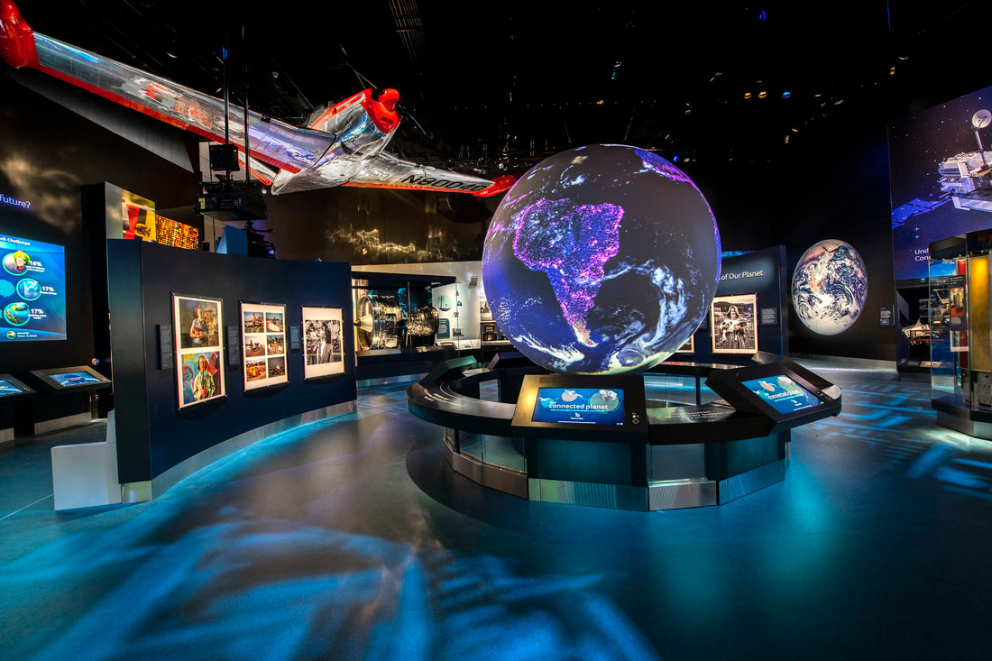
IMAGE: View of the inside of the One World Connected gallery.
2/16
In this training...This lesson will introduce you to providing spotlights in the One World Connected gallery at the National Air and Space Museum: National Mall Building. After completing this lesson you will have learned more about:
This lesson, and its corresponding quiz cover the very basic content that you will need to know for starting One World Connected Spotlights at NASM's National Mall Building. 3/16
One World ConnectedOne World Connected tells the story of how taking to the skies and stars fostered two momentous changes in everyday life: the ease in making connections across vast distances and a new perspective of Earth as humanity’s home. Featuring an array of satellites and other tools that have increased human connection, the exhibition asks visitors to consider how global interconnection touches their lives and to imagine how advances in technology might impact our near-future. Gallery Overview VideoPlease watch the following video to learn about One World Connected from Curator Teasel Muir-Harmony. This section of the training is 23 minutes long. This video is fully captioned. If you would like to turn the captions on, click on the button in the bottom right corner of the video screen that says "CC." 4/16
IntroductionAviation and Spaceflight Connect the World Not so long ago, a small village was a person’s whole world. Today, air and space technologies connect everyone on Earth—through travel, communications, and satellite imagery. IMAGE: A view of Earth from space. 5/16
How Did We Become One Connected World?Becoming One WorldCenturies ago, people walked across villages, fields, or mountains to connect with each other. Over time, travel by horse, boat, train, and car brought more of the world within reach, linking people and places far away. With the invention of airplanes, jet engines, and satellites, we have a broader view, and we can travel and communicate with incredible speed. Our understanding of our planet shifted: Earth was becoming one connected planet—one global neighborhood. Airplanes Make Us More MobileIn the early days of air travel, propeller-driven airplanes let us travel faster to places farther and farther away. They helped us create a growing web of connections—building increased trade and diplomatic relationships between nations. But airplanes also heightened our national conflicts when used as weapons of war. After World War II, the use of powerful jet engines scaled up our speed and our global reach. Jets helped postwar societies prosper—especially the United States and Europe—as more people traveled for business or pleasure. The jet airplane became a symbol of prestige and mobility. Object Highlight: Beechcraft 35 Bonanza Friendship Flame, 1947 In the unsettled aftermath of World War II, the United States and the Soviet Union were locked in a competition for global influence and prestige known as the Cold War. Starkly different approaches to politics and economics prompted an arms race between the two countries. People were looking for ways to promote friendly relations in an era when nuclear war was a real threat. In 1951 and 1952, Congressman Peter F. Mack Jr. flew this Beechcraft 35 Bonanza aircraft—the Friendship Flame—on a round-the-world goodwill tour, visiting 31countries on three continents. He met with ordinary citizens and dignitaries, promoting peaceful dialogue. Diverse Stories: Peter Mack Jr. IMAGE: Congressman Peter F. Mack Jr., wearing a life jacket and a flower lei, waves from beside the Beechcraft 35 Bonanza Friendship Flame after landing at Honolulu, Hawaii, on January 136, 1952. “By appearing personally, I believe our idea of a desire for peace can be presented to these people in a way they’ll never forget.” – Peter Mack Jr., 1951 Representing Illinois’ 21st district, Peter Mack Jr. served seven terms in the U.S. Congress, from 1949 until 1963. Following his goodwill tour, he was known as the “Flying Congressman.” At each city on the tour, Mack presented a friendship scroll from the people of his district. Key stops included Middle Eastern countries emerging from colonial rule, and Korea in the midst of its Cold War conflict. Upping the Power: Jet Engines People worldwide became more mobile and connected when jet engines were introduced into commercial aircraft in the 1950s. Since then, jet technology has become increasingly powerful and efficient. Object Highlight: CFM56-2 Turbofan Engine, 1970s This CFM56-2 turbofan engine was developed in the 1970s. The CFM family of engines became the most widely-used jet engine design in commercial aviation. This engine also reflects the impact of the 1970s environmental movement. It was designed to be quieter than earlier versions, in response to concerns about air traffic noise pollution. Communications Before SatellitesPrior to the 1960s, long-distance communication via radio, telephone, and television networks was a challenge. Local areas often had very good coverage, and broad networks might blanket a nation, but the whole world wasn’t yet covered. The existing technology—including undersea telegraph cables and radio and television receivers and reflectors—had limits in reaching distant places, especially across oceans. The result: communications were slower, shorter-range, and lower-quality than we’re used to today. Object Highlight: Shortwave Radio Receiver, RCA Model 6Q1, 1930s Bouncing Signals Off the Sky: Shortwave Radios Before satellites sent us news and music from far away, people used shortwave radios. They received “shortwaves” that bounced off Earth’s atmosphere. This technique was often unreliable but did allow communications with other continents. Object Highlight: Television Receiver, Hallicrafters Model 505, 1948 Changing Our Everyday Lives: Television In the late 1940s, less than 1% of U.S. families owned a TV set. Even though television was brand new, it soon became a critical way for leaders to speak to the public. Object Highlight: 3 TAT-1 Undersea Cable Sample, 1956 Connecting Continents: Undersea Cables When the first two undersea telephone cables were laid in 1956, people finally could make routine calls across the Atlantic. Each cable initially could only carry 36 calls at once, so the system was still very limited. Object Highlight: Operation Moon Bounce Globe, Late 1950s Using the Moon as a Communications Satellite The U.S. Navy’s Operation Moon Bounce beamed radio signals to the Moon that bounced back to another location on Earth. This system made it easier for the military to send long-distance messages during the Cold War. This lighted globe helped radio operators see which half of the Earth was facing the Moon—showing when and where moon-bounce messages could be sent. Object Highlight: Teleprinter for Pentagon Hotline, Russian Model T-63, 1963 Creating a Cold War Hotline Realizing that a misunderstanding or mistake might trigger a nuclear war, the United States and Soviet Union established a “hotline”—not a telephone, but a teleprinter. Print seemed the best way to send a very clear message. The hotline ran on the TAT-1 undersea cables. Made in East Germany and provided by the USSR, this object was placed into operation in the original Washington–Moscow hotline circuit Communications Satellites Close the Gaps By the mid-1960s, communications satellites had become reliable tools. Satellites positioned in high orbits could “see” large swaths of Earth, allowing them to receive and send signals to and from distant places. Satellites brought radical change, filling in communication gaps and providing telephone and television connections nearly worldwide. Television could now provide hundreds of millions of people across the globe with ground-breaking news and images. Soon the tagline “live via satellite” became a staple of TV viewing. Object Highlight: SCORE (Signal Communications by Orbital Relay Equipment), 1958 In 1958, President Dwight D. Eisenhower used SCORE—the first communication satellite—to broadcast a Christmas message: “Through this unique means I convey to you and all mankind, America’s wish for peace on Earth and goodwill toward men everywhere.” Object Highlight: Communications Satellite, Relay 1, 1963 President Kennedy's Funeral in Real Time In November 1963, the Relay 1 satellite sent TV images of President John F. Kennedy’s funeral to Europe and Japan, allowing millions of people to grieve along with the United States. With Relay and other experimental communications satellites, news from distant places became a regular part of everyday life. Object Highlight: Intelsat II Communications Satellite, Flight Spare, 1966 Intelsat II satellites like the one overhead were placed in Geostationary Earth Orbit in the mid to late 1960s, creating the first communications network that was nearly global in scope. Thanks to these satellites, the reach of telephone and television service became more widespread and reliable. Intelsat stands for International Telecommunications Satellite Organization, an international treaty organization formed in 1964 to improve communications, especially for developing nations. Broadcasting Our Humanity The Beatles’ All You Need Is Love debuted in 1967 on a live BBC television program—Our World—beamed worldwide via a combination of satellites, including an Intelsat II satellite. The song echoed the show’s theme about humanity sharing similar problems and dreams. Seeing the First Moon Landing IMAGE: This television image of Neil Armstrong taking his first step on the Moon, July 20, 1969, was shared with millions via satellite (SOURCE: NASA). As astronaut Neil Armstrong stepped onto the Moon’s surface in 1969, one-sixth of Earth’s population watched via Intelsat satellites. The iconic images were grainy and blurred, but they changed our sense of the world and our relations with each other. Object Highlight: OSCAR I (Orbiting Satellites Carrying Amateur Radio) Without Antenna, 1961 Amateur Radio Enthusiasts Join the Satellite Era OSCAR I was the first amateur satellite, built in 1961 in garages and basements for $68. It piggybacked on a government rocket launch and operated for nearly 20 days. Thousands of radio operators in 28 countries detected its message. Picturing Earth from Space Before the Space Age, people could only imagine what Earth looked like. Artists tried their best, and in time, new technologies started to piece together a more accurate picture. High-altitude rockets, satellites, and human space missions gave us increasingly dramatic views. In 1950, Scientific American had to rely on artist Chesley Bonestell’s conception of Earth as seen from space, not on an actual photograph. Object Highlight: GRAB (Galactic Radiation and Background) Satellite Ground Station Contact Map, 1960 Using Satellites for Spying GRAB was the first electronic spy satellite; it picked up radio communications from Cold War adversaries. Ground operators used this map to tell when the satellite was overhead. That’s when they could download intercepted intelligence. Seeing Earth from Space: A New Era Begins Artists and writers had imagined Earth as seen from space, but viewing the world through astronauts’ eyes was something else altogether. A flood of images—taken by astronauts and by satellites—appeared in both print and TV news. They had a powerful impact: here was Earth—our home planet—in all its beauty and fragility. The view from space brought opportunities to study and predict the weather and to see the effects of humanity’s hand on the environment. Object Highlight: Whole Earth by Chesley Bonestell Before spacecraft gave us actual photos, artist Chesley Bonestell created renderings of space and its worlds in dramatic detail. This view shows Earth from 20,000 miles (32,000 kilometers) up during the 1950 summer solstice. The three views are shown as Earth would appear in different wavelengths of light: infrared, visible, and ultraviolet. Object Highlight: Aerobee 16 mm Movie Camera, 1954 The Aerobee rocket carried a motion picture camera that could record views from 100 miles (160 kilometers) above Earth. At the height of its trajectory, the Aerobee rocket’s nose tipped down, allowing this color camera to see a million square miles (2.6 million square kilometers) of the planet’s surface. Object Highlight: Aerobee Camera Mosaic, 1954 This photomosaic of Earth patches together 117 separate images taken by a camera on board an Aerobee rocket. Do you see a swirling cloud on the upper left side? It’s a remnant of a tropical storm over the Baja peninsula in Mexico. The photomosaic image gave us an early hint of how space views could revolutionize weather forecasting. This diagram pinpoints the geographic areas shown in the photomosaic. The curved edge of the photo isn’t showing the curvature of Earth; it just shows the limit of the camera’s view. Object Highlight: Hasselblad 500EL 70 mm Camera, 1968 Using this Hasselblad camera, astronauts photographed Earth on the first crewed round-the-moon space journey—the Apollo 8 mission in December, 1968. An astonishing image taken by William Anders was soon immortalized as Earthrise, becoming a profound symbol for humanity and Earth’s place in the cosmos. The photo was adopted as an icon of the environmental movement. Object Highlight: William Anders’ Checklist, Apollo 8, 1968 Remember to Take Photos! This detailed checklist reminded astronaut William Anders to take photographs—for scientific purposes and to convey the story of space travel to everyone back home. Watching Global Weather from Above With satellites providing “above the Earth” views, meteorologists could see not just local clouds, but whole weather systems. This perspective helped them better understand the atmosphere’s dynamics. Over time, satellite images and data became essential to daily weather forecasts, making them more accurate and timely. Object Highlight: TIROS (Television Infrared Observation Satellite) Meteorological Satellite, 1960 Tracking the Weather from Space Carrying two video cameras and tape recorders, TIROS was the first weather satellite. The camera design used shutters to produce still photos. These images were stored on the recorders, then transmitted back to Earth where they could be stitched together to show larger weather patterns. The Power of Astronaut Images of Earth Photographs of Earth taken by America’s first astronauts were published prominently in newspapers around the world—starting with John Glenn’s 1962 Mercury mission and continuing through the last Apollo mission in 1972. These images changed our relationship with Planet Earth by showing what the astronauts saw with their own eyes: the scale, fragility, and beauty of a colorful world, dappled with white clouds. The Whole Earth in One Frame Traveling to the Moon in 1972, Apollo 17 astronauts captured images of a whole Earth, unobscured by lunar shadows. This photograph, often called the Blue Marble, had an immediate impact on popular culture, politics, and the emerging environmental movement. Seeing our world with no apparent national borders, we could view ourselves as linked by our common humanity. The impact of such photographs continues, even today. Inspiring the Environmental Movement In the 1960s and 1970s, concerns for the environment grew into a social movement—in the United States and worldwide. The beauty and power of space-based images energized the movement. Seeing a blue Earth in the vastness of space emphasized the uniqueness and fragility of our home and our responsibility to act on its behalf. Object Highlight: Earth Day Flag, 1970 Originally created to celebrate the Apollo 11 Moon landing, this flag became an icon of the first Earth Day—April 22, 1970. Earth imagery symbolized how our everyday actions—for good or ill—affect the planet’s environmental health. "Planet Earth" Takes on a New Meaning Aviation, satellites, and human spaceflight gave new meaning to the words “Planet Earth.” We had become more connected and more global in our thinking—more aware of our interdependence. What will this new mindset mean for our shared future? Does the speed of our connections bring us together —or make life more complicated? Can people with different politics and cultures find common ground? Artists Pictured a World that Could Be With images from space to inspire them, artists in the 1960s and 1970s embraced the idea that the people of Earth could share their common humanity. Somehow, reaching across age-old divides now seemed possible. 6/16
Understanding Our Connected Planet Wind, rain, fire, earthquakes—they change our world, right before our eyes. We also see Earth change when people plow, plant, and build. But for millennia, our view has been nearsighted. Today, satellites with their cameras and sensors let us see and study an evolving Earth—on a huge scale and in fine detail. The result is a better understanding of how Earth functions and how our actions have impacts on the land, water, air, and climate. Satellites Reveal an Ozone Hole IMAGE: The ozone hole over Antarctica changes through the seasons—growing in July as winter begins and reaching its maximum annual size in late September. In the mid-1970s, scientists theorized that gases in common products—hairsprays, aerosol deodorants, and refrigerants—could cause a serious problem. When released, these gases could drift upward and damage Earth’s atmosphere. The damage would occur when the gases interacted with the Earth’s ozone layer—a protective shield that blocks dangerous ultraviolet radiation from the Sun. A decade later, satellite imagery revealed a huge hole in the ozone layer over Antarctica—confirming the theory and providing startling evidence of human impact on a global scale. In 1987, production of these hazardous gases was banned by a unanimous United Nations treaty. Picturing a “Hole” in the Air The “ozone hole” is a region in the atmosphere where the ozone level is dangerously low. But in images generated from satellite data, a low-ozone area looks like a hole. Diverse Stories: Susan Solomon Pioneering Atmospheric Scientist Working from the theory that gases called CFCs (chlorofluorocarbons) could deplete ozone from our atmosphere, Susan Solomon provided the proof. In the 1980s, she led expeditions to Antarctica, gathering evidence showing the interaction between CFCs and atmospheric ozone. Her research was vital in establishing the global ban on ozone-depleting gases. Solomon’s interest in atmospheric science dates back to high school, where her research on gases took third place in a national science contest. In 2007, she and others on the U.N.’s Intergovernmental Panel on Climate Change shared the Nobel Peace Prize with former Vice President Al Gore Jr. Object Highlight: Microwave Limb Sounder This is an engineering model of the instrument that flew on the Upper Atmosphere Research Satellite (UARS). The instrument studied the “limb” of Earth—its outer atmosphere—measuring ozone and other atmospheric compounds. Object Highlight: Rexall Brite Set Hair Spray, 1960s Aerosol hairsprays and deodorants were among the culprits that created the ozone hole, due to the gases they released—chlorofluorocarbons (CFCs). Surprisingly, just a little spray—billions of times over—did tremendous damage. Object Highlight: SAM (Stratospheric Aerosol Measurement) II Instrument, 1978 A SAM II instrument like this engineering model flew on the Nimbus 7 satellite, collecting data on aerosol concentrations in the atmosphere over the poles. The data helped scientists study the ozone hole and develop computer models of Earth’s climate. Satellites Show the Link: CO2 and Climate Change IMAGE: Factories burn fossil fuels in the Great Lakes region, Toledo, Ohio, 1970. SOURCE: The Blade (1970) Cars, homes, and factories that burn fossil fuels—gasoline, oil, natural gas, or coal—emit carbon dioxide (CO2), a gas that traps heat around our Earth. While the CO2 level has varied over Earth’s history, human activity is causing it to increase. Any significant increase in CO2 levels can have serious consequences for Earth’s climate. As the debate continues about how best to face this reality, satellites provide data to help scientists analyze CO2 effects. How does CO2 affect Earth’s climate? CO2 traps some of the Sun’s heat around our Earth, adding to rising global temperatures, a main feature of climate change. Object Highlight: Earth Radiation Budget Experiment Instrument, Engineering Model, 1980s Satellites carried Earth Radiation Budget Experiment instruments, gathering data on Earth’s “radiation budget”—the balance of heat energy entering and leaving the atmosphere. Scientists use this evidence to create more accurate climate-change models. Object Highlight: General Motors EV1 Electric Automobile, 1990s Seeking Climate-Change Solutions Satellites helped make the case that automobile emissions were changing Earth’s atmosphere. These concerns spurred the development of low-emission electric-powered vehicles. General Motors’s EV1 was the first to be designed for the mass market. Object Highlight: Microwave Sounding Unit, Flight Spare, TIROS N Meteorological Satellite, 1984Taking the Atmosphere’s Temperature By measuring the temperature of the atmosphere from Earth’s surface to 12.4 miles (20 km) above, microwave sounding units let scientists track warming trends. They flew on TIROS satellites, starting in the 1970s. Evidence of Climate Change IMAGE: The Lower Atmosphere, Troposphere, (top image) and the Upper Atmosphere, Stratosphere, (bottom image). Temperature measurements of the atmosphere taken by microwave sounding units from 1979 through 2005 show that the lower atmosphere is warming, which leads to cooling in the upper atmosphere. Satellites Show Our Impact on the EnvironmentIMAGE: Satellite images show the Aral Sea (Kazakhstan and Uzbekistan), has shrunk due to water diversions for farming. The exposed salty seabed harmed the region’s agriculture. Our modern world supports billions of people with its bountiful food and goods, but at a cost to the environment. The crops we grow, the resources we use, and the garbage we discard all have an impact. Satellites and the sensors they carry are powerful tools for monitoring and providing data. They help people reverse the damage to environments worldwide. Object Highlight: Scan Line Corrector, Landsat 7, 1999-2003Satellite photos are taken in strips that require a special instrument—a scan line corrector—to align them and make them more readable. A scan line corrector like this engineering model flew on Landsat 7’s Enhanced Thematic Mapper Plus. Object Highlight: Vidicon Tube, Landsat 1, 1972Video cameras onboard Landsat 1 gathered data on Earth’s surface features, such as vegetation and geology. A vidicon tube, like this example, was one of three in a camera, designed for gathering data at different wavelengths. Object Highlight: Coastal Zone Color Scanner Radiometer, 1970sRadiometers like this flight spare, measured different wavelengths of light, gathering data on the Earth’s oceans. Different colors show the oceans’ chlorophyll levels, salinity, and temperature as indicators of the oceans’ health. Object Highlight: Clam Shell ContainerIn the 1980s, polystyrene-foam containers symbolized the wasteful habits of American industry and consumers. These disposable containers not only ended up as non-biodegradable trash, they also released CFCs, contributing to the ozone hole. Satellites Keep an Eye on Animal LifeDo we have a role to play in protecting animals that become endangered on our watch? Satellite technology, especially the Global Positioning System (GPS), is proving to be a valuable tool in researching that question. Monitoring devices attached safely to sharks, birds, elephants, and other animals allow scientists to monitor their movements and migrations and to study their behavior. These data help scientists develop improved strategies for wildlife conservation. Object Highlight: Shark Tag, Argos Satellite Network, 2010sUsing Satellites to Follow Sharks The Smithsonian Environmental Research Center used this type of tag to track bull and dusky sharks. The tag activates when a shark surfaces, sending location and water temperature data to a satellite above. Tiny Enough to Track a Bird Some satellite tracking tags are so small and lightweight, they are suitable for birds. Tags like this allowed scientists at the Smithsonian’s National Zoo to study gulls’ migratory routes, which can extend thousands of miles. Computers Power Up to Tackle Climate DataIMAGE: This view of Earth shows dust (red), sea salt (blue), organic carbon (green), and sulfates (white) in the atmosphere, which prevent the transmission of light and influence Earth’s weather and climate. Satellites and all the instruments they carry generate vast amounts of information about Earth’s climate and its physical systems. Combine that with information from instruments on the ground and in the air, and it’s a lot to process. For climate study, powerful computers help scientists combine and analyze all the data, forming digital models that can detect patterns and predict future trends. Climate models, refined by new data and now extending over decades, indicate that human-generated CO2 is warming Earth’s climate. Object Highlight: Cray-1 Supercomputer, CPU (Central Processing Unit), 1980sUsing a Supercomputer for a Colossal Job The National Center for Atmospheric Research used this “supercomputer” in the 1980s to model the behavior of the Earth’s atmosphere. This effort required a huge range of complex calculations that only the Cray-1 could do. The Cray-1’s wiring, with its circuits arranged in a three-quarters circle, helped increase the speeds of signals within the computer. The first production model of the Cray-1 supercomputer weighed five tons (about 4500 kg) and had to be lowered through the ceiling of the new underground computing center at the National Center for Atmospheric Research. Hefty power supplies were located underneath the padded bench. 7/16
Communicating WorldwideCommunicating WorldwideIMAGE: Satellite dishes dot the rooftops of Fes, Morocco. Before the 1960s, to connect with people on other continents you could send a telegraph or airmail letter, or make a telephone call. These options were expensive or slow. Radio and TV also had their limits. With the development of communications satellites, international television programming and phone calls became a staple of everyday life. Individuals and businesses could connect, and countries large and small developed their own networks. “I used to do volunteer work in poor areas of Cairo, and people would gather their money together to get a satellite dish. You'd see them huddling around and for the first time seeing issues being debated on TV that had never been talked about before. And that is the biggest promoter of democracy you could possibly have.”—Jehane Noujaim, Egyptian American documentary film director, 1990s Satellites Reach the Developing WorldAfter World War II and the collapse of old European empires, dozens of independent countries were created. A new world was emerging, with complex politics and disparate levels of wealth and power between old and new nations. One driving question was how to use technology to empower developing countries, improve their economies, and support their cultures. Communications satellites came to play a special role in this effort. They could transmit information for governments, businesses, and communities—giving developing nations more ability to define their own futures. Object Highlight: ATS-6 Communications Satellite Antenna, 1974–1979See the huge disc overhead? It’s a full-scale engineering model of an antenna on the ATS-6 satellite. Sponsored by NASA, this 1970s satellite tested new technologies for space communications. This model was used to assess the effects of launch vibration and the extreme temperatures of space. Once in orbit, the antenna opened like an umbrella, ready to send signals to small antennas on Earth. For the first time, many remote communities could benefit from space communications. ATS-6’s most significant effort was the Satellite Instructional Television Experiment, which provided programming on health, education, and agriculture to rural villages in India. Diverse Stories: Vikram SarabhaiFather of the Indian Space Program As one of the primary architects of the Indian rocket and space program, Vikram Sarabhai (1919–1971) believed that science and technology could transform his country. He felt that an Indian space program promised both self-reliance and economic benefits. Sarabhai’s efforts led to the creation of the Indian Space Research Organization (ISRO). In the 1970s, ISRO collaborated with NASA on the Satellite Instructional Television Experiment, which provided educational programming to 24,000 Indian villages and led to the development of India’s own satellites. Connecting with Africa, South Asia, and the Middle East IMAGE: Students at Khadija Umul Mumminin girls’ primary school in Mandera, Kenya, listen to an English lesson on WorldSpace satellite radio in 2002. WorldSpace satellites used low-cost radio receivers. This was an early attempt to provide educational programming, disaster relief communications, and entertainment to areas where the communications infrastructure wasn’t yet well developed. The Global Phone NetworkIMAGE: This 1965 publicity photo shows Intelsat 1 “Early Bird” with hundreds of phones. The communications satellite was the first to provide regular, everyday service between North America and Europe. Making international phone calls changed radically with the development of communications satellites. Within their first two decades, satellites achieved farther reach, more capacity, and more flexibility than their only competitor—undersea telephone cables. They provided a vital means to connect people and places far away. Object Highlight: Traveling Wave Tube Assembly, early 1990sBoosting a Satellite’s Signal In traveling 22,400 miles (36,049 kilometers) from Earth to a satellite, radio waves lose strength. To compensate, a traveling wave tube on the communications satellite amplifies the signal, producing a stronger one to send back to Earth. Specialized Satellites The satellites represented by these models (Marisat (top left), Tacsat (top right), Comstar (bottom left), and Intelsat VI (bottom right)) were all “spinners”—rotating to stay stable in orbit. But each served a different purpose—specialized for military, maritime, business, or general communication uses. Solar Cell Test Panel, Intelsat VI, late 1980sProducing their Own Power Satellites need power to run their systems. They generate their own using solar cells—converting sunlight to electrical energy, which is stored in batteries. This test panel represents a state-of-the-art cell for its time. Spinning to be Stable Similar to the spin of a Frisbee, spinning helped stabilize “spinner” satellites. It also kept one side from heating up more than another. What are the Main Parts of a Communications Satellite? Most communications satellites have the same basic components:
Radio-wave signals travel from a transmitting station on Earth up to a communications satellite. Then the satellite processes the signals and relays them to a receiving station back on Earth. Satellites let us send radio waves, which only travel in straight lines, around the curve of our planet. Why use Geostationary Earth Orbit? At Geostationary Earth Orbit, a satellite moves at the same speed and in the same direction as Earth, creating a stable communication pathway between far-apart places. How Do Satellite Orbits Differ? Some satellites orbit the Earth in circles while some travel in ellipses. Depending on their orbital distances from Earth, most satellites fall into one of these groups: Orbit NameDistance from Earth Low Earth Orbit100 up to 1,240 mi (160 up to 2,000 km) Medium Earth Orbit1,240 up to 22,240 mi (2,000 up to 35,790 km) Geostationary Earth Orbit22,240 mi (35,790 km) Satellites also orbit at different orientations relative to Earth’s equator or poles. Satellites that are in Geostationary Earth Orbit circle the Earth around its equator from a distance of 22,240 mi (35,790 km), and match the Earth’s rotation. These satellites appear to “stand still” in the sky. Object Highlight: Echo Canceller, Engineering Model, 1970sImproving the Sound of Satellite Calls Radio waves take time to travel round-trip to a satellite in Geostationary Earth Orbit. Additional delays occur with signal processing. Annoying echoes can result, but this device cancels them out, clearing up phone conversations. Satellites Work Together With Undersea Cables As important as satellites became, undersea cables are the mainstay of the global phone network. In the 1980s, the old cable technology was updated: instead of copper wire, the new cables used fiber optics, in which strands of glass transmit information via light waves. Fiber optic cables can transmit more information than copper cables and even more than satellites. But these cables have their limits too. They connect shore to shore but then depend on land-based networks to keep the information flowing. Satellite communications complement this infrastructure to provide phone, TV, and data service over the entire planet. Object Highlight: Fiber Optic Cable Sample, mid-1980sUndersea Cables Are Tough Cables like this one contain elongated glass fibers inside a sturdy housing. The cable needs to stand up to the ocean’s hazards, which include corrosion, high pressure, ship anchors, and fishing activity. Object Highlight: Undersea Fiber Optic Cable Amplifier, 1984Boosting Undersea Signals As a signal travels along an undersea fiber optic cable, it weakens. To solve this problem, the cable runs through amplifiers like this one, which boost the signal and maintain its integrity. Overseas Talk by Undersea Cables More than 95% of international phone calls, internet usage, and data transfer is transported by undersea cables. There are more than 550,000 miles (885,000 kilometers) of undersea cables around the world today. Satellites Make Cultural Connections Like airplanes earlier in the 20th century, communications satellites became key symbols of progress and international good will. For developing countries, these satellites took on special meaning, tied to national aspirations and affirming each country’s distinctive culture. Satellites built for Indonesia, Mexico, and other nations broadcast their own educational and cultural programming, providing a new way to create a sense of national identity. At the same time, satellite networks linked these nations to the world community. Object Highlight: National and Regional Satellite PostersCelebrating the Advance of Technology These posters showcase the importance of space technology to a country’s life and history by combining satellites, views of Earth, and national cultural symbols. Object Highlight: Japanese Satellite TV Dish, 1980sEven with Different Equipment, We Can All Connect Satellites connect the world, but each country has its own way to use them. In the United States, a small parabolic satellite dish is common. In Japan, people initially chose this flat, square design. 8/16
Living in Our Connected WorldBy the 1990s, more and more people were able to connect with each other. Technology broadened our horizons—through satellite views of Earth, cell phones, the internet, satellite radio, far-reaching air travel, and global positioning systems. Together, these developments shape the routines of daily life, affecting us in ways visible and invisible, and in different ways depending on where we live. Every Day, We See Earth from Space Images of Earth from space are all around us, with new views every day. The International Space Station (ISS) provides a steady stream of images showing the grandeur of our planet. Mapping programs on our phones and computers give us detailed images of our neighborhoods. We see the Earth often and from different angles and distances, bringing the near and far into everyday life. Object Highlight: ISS Cupola Trainer ReconstructionThe ISS Cupola—an Eye on a Wondrous World Every 90 minutes, astronauts in the Cupola of the International Space Station (ISS) can see the sun rise. From the domed observatory’s seven windows, they look upon Earth from 250 miles (400 kilometers) above the planet’s surface. They see wonders of the natural world and, quite often, signs of human activity. Even though such views are now familiar, when you step back and think about it, they’re still awe-inspiring! Cupola’s Window on Earth The ISS Cupola was designed and built in Italy. It always faces Earth so astronauts can see the planet from different angles. Preparing Astronauts to Observe Earth Since 2010, astronauts on the ISS have made scientific observations from Cupola windows like these—tracking weather events, pollution, and atmospheric activity. They trained on simulators at NASA’s Johnson Space Center in Houston, Texas. Object Highlights: Photography Equipment (Nikon Camera, Camera Lenses, Lenovo Laptop Computer, Timer-Stopwatch)Taking Out-of-this-World Photos When working in the Cupola, astronauts used equipment like this to plan and capture images of Earth. Astronauts keep several cameras handy so they don’t need to change lenses or camera settings while speeding above the Earth in the weightlessness of space. Experiencing the “Overview Effect” IMAGE: Aurora borealis above Sweden, 2015 Many who have flown in space were overcome with awe when they saw Earth from high above. This “overview effect” increased their desire to protect humanity and our fragile planet. Diverse Stories: Chris HadfieldRenaissance Astronaut Onboard the ISS, Canadian astronaut Chris Hadfield recorded his own version of Space Oddity, the classic David Bowie song. It included views from the Cupola—a truly special space. The online video went viral, reaching tens of millions of viewers. During his missions, Hadfield focused on connecting with people back on Earth. For his many social media followers, he made internet videos about how fluids, materials, and the human body behave in space. Object Highlight: Planet Labs "Dove" Imaging Satellite, 2015Making Space Imagery More Accessible Small “off-the-shelf” satellites became a new way of imaging Earth from space in the mid-2010s. A set of satellites like this one can photograph the entire Earth in just one day. IMAGES: A Dove satellite took these photographs before (left) and after (right) a tornado tore through Sidney, Illinois, in 2016. Living in Our Connected WorldBy the 1990s, more and more people were able to connect with each other. Technology broadened our horizons—through satellite views of Earth, cell phones, the internet, satellite radio, far-reaching air travel, and global positioning systems. Together, these developments shape the routines of daily life, affecting us in ways visible and invisible, and in different ways depending on where we live. Mobile Communications Circle the Planet Satellite constellations in lower-Earth orbits help make mobile communications easy. They fill in where ground-based systems, such as undersea cables, leave off. Together, these systems connect people through credit card networks, mobile phones, satellite radios and the internet. We can do business, talk, listen, and learn—almost anywhere in the world. Object Highlight: Motorola Satellite for the Iridium System, 1996 Making Satellite Calls Anywhere and Everywhere In 1998, a network of 66 Iridium satellites allowed users to make mobile phone calls and send data from anywhere in the world—a first in the history of telephones. The satellites fly in Low Earth Orbit, circling from one pole to another. IMAGE: This 1998 Iridium advertisement let customers know that their calling range was the entire planet. Iridium designed the system for global travelers and people in remote areas. The U.S. government used the Iridium system extensively in the conflicts in Afghanistan and Iraq. Object Highlight: Iridium Satellite Phone, 1998Reaching Out with the Iridium Phone The antenna on this Iridium phone links directly to the satellite network. Users can call and send data to or from the South Pole, the Sahara, or a ship at sea. No place on Earth is too remote for communications anymore. IMAGE: Capt. Rob Selmer and Tech. Sgt. Quentin Nemechek make an Iridium phone call from Pegasus Field, Antarctica. Moving Money Around the World When you use a credit card, your financial information travels along a cable or satellite network. Wide use of credit cards began in the 1970s, making worldwide travel and payment much easier. Object Highlight: Nokia 1100 Mobile Phone, early 2000sUsing Mobile Phones to Build Businesses A small-business operator in Kenya used this phone for his financial transactions. Even without local banks, entrepreneurs can use mobile phones to take part in micro-finance programs and connect with buyers and sellers. Object Highlight: Laptop Computer, One Laptop per ChildConnecting Children to the Internet One Laptop per Child designed this small, durable laptop. The organization provides computers to bring new educational opportunities and internet access to millions of children worldwide, including many in the United States. IMAGE: Children from Corazon de Jesus School, a participant in the One Laptop program since 2016. The program helps 149 students and 5 teachers in Chiquilistagua, a rural area near Managua, Nicaragua. Object Highlight: PropCube, Engineering Backup, 2014Building Customized Satellites, Small But Mighty CubeSats are small satellites built from one or more modules of standard size, making them inexpensive and easy to launch. This one-module Propagation CubeSat, a flight backup, was part of a classified program to study how changes in the Earth’s upper atmosphere affected communications. Object Highlight: MicroSat Amateur Communications Satellite, Mechanical Test Model, 1990sKeeping Satellites Simple Amateurs pushed the idea that small, simply-built satellites could do serious work in space. The antennas on this modular satellite are made from strips of a household tape measure. Object Highlight: XM Car Satellite Radio Receiver, 2001Test-Driving a New Kind of Radio Lon Levin, a founder of XM Satellite Radio, used this radio—adapted to receive satellite signals—in his own car to promote his new business. It was the first such unit ever built. Object Highlight: Sirius FM-4 Communications Satellite, Flight Spare, 2000Listening to the Radio via Satellite The first generation of space-based, commercial radio service was developed by Sirius Radio (later Sirius XM Radio). Service to North America started in 2001 with three satellites and more than 150 channels. Satellite radio became popular for use in automobiles. With standard radio, the signal fades as vehicles leave a radio station’s range. But satellite radio stays tuned in—coast to coast. The stowed solar panels on this satellite would span 78 feet (24 meters) once opened in space. The Speed of Money in a Global World Money “travels” around the world at the speed of light—electronically via satellites and cables—when governments, businesses, banks, and people make financial transactions. To fully take part in this system, all nations— especially developing nations—need increased communications access. New Networks and Computers Expand Internet Access As the internet expanded, it became clear that it needed to reach further to provide access for less-affluent people and less-connected regions. In response, more affordable networks and computers were produced. This effort continues, increasing the ease of internet use worldwide. Providing Internet Access to Make Connections In regions that aren’t yet well served by communications technology, affordable internet access helps people stay connected. OneWeb antennas connect people in equatorial regions to the wider world using low-Earth orbit satellites. Smaller Satellites Swarm Earth As electronic devices get more compact and powerful, satellites do as well, making it easier to deploy large constellations of small satellites. This approach has led to new ways to communicate, photograph, and conduct science. New Approaches Help Us Move Goods Globally Today, we’re used to seeing standard-sized shipping containers on boats, trains, and trucks. Other standard containers get loaded onto airplanes too. These containers revolutionized shipping—another aspect of connecting our world more efficiently. The global market for goods allows quick shipment of perishable goods by air from anywhere in the world. International products are now common on store shelves and in our homes. Object Highlight: GLU-925 Multi-Mode Receiver (MMR), 2000sGuiding Airplanes Safely This boxy structure sits behind a plane’s cockpit displays, providing information for the displays regarding the plane’s position. By using GPS and other technologies, it helps air traffic controllers precisely manage flights at busy airports so the planes can ship goods (and people) more safely. IMAGE: A multi-mode receiver is located behind the instruments in this Airbus A380 cockpit. Object Highlight: Handheld GPS (Global Positioning System) Receiver, “Trailblazer XL” 1990sPinpoint your Position This handheld GPS receiver was one of the first available for consumer use. It used accurate time signals from satellites to pinpoint the user’s latitude, longitude, and altitude. Object Highlight: Exodus III and Exodus VIIMAGE: Exodus III (top image) and Exodus VI (bottom image). Artist’s View of Global Transport Networks In these sky-high views [above], British photographer Marcus Lyon explored the topic of globalization. His work makes us consider how our world is changing with the faster transport of more goods and people. Object Highlight: MDIS “PathMaster” GPS Control Display Unit, 1990sNavigating by Satellite Designed for use in automobiles, the “PathMaster” combined GPS signals with map data to give drivers on-screen, turn-by-turn directions. Later generations of this device are now standard equipment in cars and as mobile phone applications. What’s better, GPS or road maps? Navigation systems like GPS provide directions, traffic information, and time in route. Paper road maps can be harder to handle, but they show larger areas and can foster a sense of adventure by letting you make decisions. Satellites for Tracking and Navigation The Global Positioning System—GPS—and other such systems rely on positioning and navigational satellites. These satellites send a constant stream of signals to our phones and cars that allows us to determine our position. GPS can give us driving directions, help us produce maps, and make bank transactions. Positioning systems also allow the military to guide missiles and remotely-piloted vehicles. These systems have brought about one of the great revolutions in our everyday lives—to be able to see where people and things are located, anywhere on Earth. Object Highlight: Boeing Insitu ScanEagle UAS (Uninhabited Aerial System), 1990s–2010sMonitoring on the Fly The ScanEagle is a GPS-guided drone. It was first used as a scout craft for tuna fishing fleets. Over time, the U.S. Navy and Marine Corps used it for warzone observations, providing intelligence, surveillance, and reconnaissance, or relaying communications. Object Highlight: Boeing 747 Freighter, early 1990sSpeeding Up Shipping by Air This freight airplane model shows how efficient shipping has become. Standardized containers maximize storage and make loading and unloading faster through the hinged nose opening of the aircraft. Future of Our WorldOur web of connections will shape human life and the health of the Earth for many years to come. As we look ahead, human creativity will certainly give rise to more innovative technologies and networks. But increasing our connections brings both benefits and risks.
Think about how you will help shape the planet that we leave to future generations. Imagining How Technology Could Shape the FutureIMAGE: The Unisphere and the Court of Nations at the New York World’s Fair, 1964. Science and technology have increasingly influenced our lives over the last two centuries. Often we’ve seen the future as one innovation after another, not always aware of the changes they might bring. World’s Fairs throughout the 20th century showcased these innovations and looked with excitement for whatever life-changing inventions might come next. Their vision of the future was hopeful and optimistic. Once Exciting and New A number of world-changing inventions first appeared at World’s Fairs. Have any of these had an impact on your life? Which seem like they’ve always existed?
Object Highlight: Unisphere Mechanical Coin Bank, New York World’s Fair, 1964Celebrating the World’s Interdependence Atop this bank sits the Unisphere, the symbol of the 1964 World’s Fair. The Unisphere represented global interdependence and was dedicated to “Man’s Achievements on a Shrinking Globe in an Expanding Universe.” IMAGE: The Unisphere still stands in Queens, New York—140 feet (43 meters) tall and constructed of stainless steel. The orbit rings help convey the sculpture’s Space Age theme. Object Highlight: FuturePhone, Concept Model, 1992Designing Phones for the Future, Again and Again For more than a century, new telephone models have symbolized technological progress and inspired new ways of communicating. This FuturePhone was an early concept for combining voice and pictures—something that seems unremarkable today. Will We Find Ways to Understand Each Other? Our numerous networks have expanded into every part of our lives, but they also increase worries that we’ll lose what makes local cultures distinct and special, and what keeps social interactions close and personal. Will interdependence bring us closer together or highlight differences of power, culture, and belief across the world’s many communities? Will our relationships become more widespread and diverse, or more shallow and temporary? Object Highlight: Book Cover, Witness to the Future, Klaus Rifbjerg, 1987Is Technology to Blame? Televisions and nuclear warfare as symbols of technology gone wrong illustrate the cover of this novel, Witness to the Future. A literary trend in the 1970s and 1980s saw the future as dark and dismal, often because of technology. Actions Today Affect Earth’s FutureThe experience of life on planet Earth is often about “right now.” Our technologies make instant connections and meet immediate needs. But our technologies also point us to the future, making us consider how human activities today will have long-term effects on our planet—for hundreds or even thousands of years. Object Highlight: Rosetta Disk, Long Now Foundation, 2004Countering Loss With Global Connections Local language dialects are disappearing as people migrate to new cities and countries. The Rosetta Disk is a physical archive that stems this loss. Nearly 14,000 pages are microscopically etched on its surface with vocabulary and usage of 1,500 languages from around the world. Object Highlight: Long Now 10,000-Year Clock Face Prototype, 2010sProjecting Our Future Impact This clock will keep time for 10,000 years—the same span as human civilization has already existed. Showing years, centuries, and the movement of stars, it was designed to dramatize our long-term impact on the planet. Rock Around the Clock The clock’s chimes will ring once every century and are programmed to never repeat the same melody over 10,000 years. 10/16
Faces of Our PlanetWhat connects you to the rest of the world? Are there objects or activities in your life that represent this connection? How do you see the future as we become more connected? We are interconnected and interdependent as never before. Yet not everyone has experienced these changes in the same way. Think of your own, or your community’s, access to the Internet. Think of how you receive television. Or where the different types of goods come from in your local stores. Dr. Martin Collins, the originating lead curator for One World Connected, and Carolyn Russo, a museum specialist and curator of art with a background in photography, aimed to answer these questions personally. Accordingly, they organized a group of contemporary photographers to work in different regions of the world to create portraits and perform interviews to see how individuals are affected by recent technological developments and changes in aerospace as it relates to a more connected planet. Photographers for Faces of Our Planet were selected based on their artistic merit and geographic locations. They include internationally acclaimed photographers like Albert Watson, Rania Matar, Isabel Corthier, Alexandros Lambrovassilis, Susana Raab, Will Wilson, David Kressler, Jeffrey Milstein, and Aline Smithson. For the exhibit, each photographer also provided an artist statement reflecting their approach to the project alongside portraits and interviews with their participants. Participants were asked:
Albert WatsonIMAGE: “I can listen to the Quran in the mountains where I am alone with my herd. Unbelievable! I never imagined that I can do all these things in this part of the world.” – Omar Afkir Hmad, Ourika, Morocco Albert Watson, Photographer (b. 1942, Scotland, United Kingdom) My first trip to Morocco was in 1978 when I went on assignment to shoot a fashion story for French Vogue. Those were the days before cell phones or the internet, and although the country had one foot in the past, it was poised to move forward. Morocco today is a vastly different place. My photographs convey some of these changes, showing how the people and places have been affected by a more modern world. Isabel CorthierIMAGE: “We haven’t the latest cell phone. . . . Anything that is happening outside of Namibia, I listen to from the radio.” – Isabella Kaunahamba Purros, Namibia Isabel Corthier, Photographer (b. 1977, Belgium) Are traditions disappearing or becoming pale variants of one dominant culture, the Western one? Or are traditions dynamic entities that find different ways on how to deal with globalization? The visited traditions seem to have adapted and changed—as a result of globalization—in ways that remain true to their most cherished values. Generally, the Namibian people hoped to be more connected to other people in the world, mainly to learn from each other. Aline SmithsonIMAGE: “I fly back to Switzerland for work or to visit family and friends. When I don’t travel, I use Skype.” – Shari Yantra Marcacci, Studio City, CA Aline Smithson, Photographer (b. 1953, United States) I have selected immigrants who have enriched my life in ways both large and small. They are people of two worlds—one foot rooted in the culture that shaped their identity, and one foot rooted in a country built on hope. I asked each person to wear or hold something they brought with them on their journey to the United States. Each object represents a significant personal connection to a place that was once called home. David KresslerIMAGE: “I hope the future will be amazing. . . . We have to think of other people for the future . . . our children. . . . We have to think a wonderful world is coming.” – Samir Kurshid, Portland, Oregon, U.S. David Kressler, Photographer (b. 1968, U.S.) Most of my work deals with how humans change the landscape to meet their needs, hopes, and desires. The artists I photographed are also concerned with how we change the planet in ways and on a scale never before possible. Modern technologies help us to migrate, explore, and make new discoveries. They shrink the distance between places and people and diffuse ideas across the globe. They bring together communities, provide connections to home, and even make political escape and refuge possible. Susanna RaabIMAGE: “Kids are more and more aware and the internet has given them more information….The next generation will be better than us taking care of the environment.” – Rosa Asca, Lima, Peru Susanna Raab, Photographer (b. 1968, Peru) Lima’s Pacific coastline is comprised of a group of beaches known as La Costa Verde, all as diverse in representation as the Peruvian people. I have long walked these beaches in search of the Peruvian identity. Facebook and the phone are the great unifiers and distributors of information for all but the oldest and most traditional. Climate change is a real concern, and Peruvians are interested in saving their glaciers and sources of water in the Andes. Jeffrey MilsteinIMAGE: “Hopefully we see the connections between all living things and their importance to each other—and begin to save the world rather than destroy it.” – Barry Koffler, High Falls, New York, U.S. Jeffrey Milstein, Photographer (b. 1944, U.S.) Artists first settled here [Hudson Valley, New York] in the 1800s, and its natural beauty fostered the Hudson River School of landscape painting. Prior to globalization, the area was also an important source of food and manufactured goods for New York City but the area became adversely affected with cheaper imports. We are seeing a rebirth of agriculture due to the demand for farm-to-table food. Also, the internet has shrunk the world making it possible to run global businesses from the Valley. Rania MatarIMAGE: “I am connected via the internet.... As a refugee, I cannot travel, but I am in touch with the world.”– Samira Abo Shaker, Bourj El Barajneh Refugee Camp, Beirut, Lebanon Rania Matar, Photographer (b. 1964, Lebanon) As a Lebanese-born American artist and mother, my cross-cultural experience and personal narrative inform my photography. My work follows my path and my daughters’ through the states of being and transformations. I am interested in what it is like to be a girl, a woman and a mother, and how we make sense of a world that poses endless questions on girls and women of all backgrounds. Finding connections between women is especially important in the current political climate we live in, where the ‘them vs. us’ rhetoric is prevalent. After all, I am ‘them’ and I am ‘us’–as we all truly are. Will WilsonIMAGE: “I hope to see the people of all nations and races begin to stand together…to save the world [and] that our future generations are given an opportunity to live without fear.”– Tashina Jean Tahdooahnippah, El Reno, Oklahoma Will Wilson, Photographer (b. 1969, U.S., Navajo) Living in Navajo Nation during my formative years has shaped the way I see myself as an Indigenous American and how I represent Native Americans through art. My work is an allegorical investigation of the extraordinary rapid transformation of the Indigenous lifeways, the dis-ease it has caused, and the strategy of responses that enable cultural survival. These responses—rather than the old paradigm of assimilation—can be the basis for a re-imagined vision of who we are as Native people. Alexandros LambrovassilisIMAGE: “I believe…humans in their core are social creatures and this requires proximity….Although we seem to be more connected, at some level we might be growing apart.” – Dimitra Aggelou, Athens, Greece Alexandros Lambrovassilis, Photographer (b. 1970, Greece) Throughout human history, people are shaped by the environment, locally and globally. I consider our physical or constructed environment to be the ‘face of our planet’ which reflects the human condition as we’ve encountered and reshaped it across the longitudes and latitudes. What is it that people see when they leave their homes to go to school, to work? How do they relate to their environment? Where is their favorite place in their village or city? 11/16
Interactive GlobeIMAGE: Visitors can interact directly with the ten-foot spherical projection via six interative kiosks that enable deeper dives into the exhibitions key themes. Each kiosk will allow visitors to pull up data visualizations on the globe itself. 12/16
One World ConnectedIMAGE: NASA Earth Observatory image by Robert Simmon, using Suomi NPP VIIRS data provided courtesy of Chris Elvidge (Source: NOAA National Geophysical Data Center). “Today, no country can ever truly cut itself off from the global media or from external sources of information; trends that start in one corner of the world are rapidly replicated thousands of miles away.” – Francis Fukuyama, American political scientist, economist, and author, 1999 13/16
vSys Shifts: Signing Up For SpotlightsYou MUST sign up for Spotlight shifts using vSys. How To Sign Up For NMB Spotlight Shifts in vSys:
14/16
Recording Your Hours in vSysAfter your shift, it is important to correctly log your volunteer hours in vSys. We report our volunteer hours and visitor interaction numbers to Central Smithsonian and Congress, so it is imperative that we have your shifts regularly and correctly logged, including visitor interaction numbers. How To Log NMB Spotlights Hours:
15/16
Next StepsAfter you complete this lesson and pass the quiz, please email [email protected] so they can add this training to your vSys profile. Please note that you must complete this lesson, pass the quiz, and complete the Q&A session with Curator Teasel Muir-Harmony (either at the live Zoom session or the recorded copy on Moodle) in order to sign up for One World Connected Spotlight shifts. 16/16
Lesson Completed!This is the end of the lesson. This lesson contains the basic information about docent spotlighting in the One World Connected gallery at NMB. You can review the lesson again using the links in the Lesson Menu block or the navigation buttons below. When you are finished reviewing the lesson, return to the Main Course Page to take the quiz. A PDF version of the lesson content is available on the main course page, for your reference. |
